Wiosenna wędrówka po Górach Pieprzowych na Wyżynie Sandomierskiej. Z parkingu w miejscowości Kamień Plebański kierujemy się czerwonym szlakiem na wschód, do Rezerwatu Góry Pieprzowe. Jeszcze przed rezerwatem, przy pierwszym podejściu na wzniesienie możemy podziwiać łupki kambryjskie, z których zbudowane są Góry Pieprzowe. W trakcie dalszej wędrówki natrafimy na łupki jeszcze kilka razy. Schodzimy ze wzniesienia nad brzeg starorzecza Wisły i po wejściu do rezerwatu wchodzimy na kolejne wzniesienie, na szczycie którego znajduje się punkt widokowy z rozległą panoramą. Następnie wędrujemy skrajem wzniesienia podziwiając odległe widoki i pięknie kwitnące krzewy róż. Przy krzyżu szlak skręca w prawo i stromym zejściem ponownie dochodzimy do starorzecza Wisły. Jego brzegiem wracamy na parking, po drodze jeszcze odwiedzając ukryte w lesie łupki kambryjskie.

🇵🇱
🚶 Wirtualna wędrówka: Spacer po Górach Pieprzowych, Polska
🏞️ Trasa: Kamień Plebański, parking (145 m n.p.m.; 50.684094, 21.778126) – Rezerwat Góry Pieprzowe (145 m n.p.m.; 50.683899, 21.783445) – Punkt widokowy (182 m n.p.m.; 50.684699, 21.785551) – Zejście z czerwonego szlaku (146 m n.p.m.; 50.684910, 21.795030) – Rezerwat Góry Pieprzowe (145 m n.p.m.; 50.683899, 21.783445) – Łupki kambryjskie (168 m n.p.m.; 50.685318, 21.783780) – Kamień Plebański, parking (145 m n.p.m.; 50.684094, 21.778126)
🆔 Oznaczenie: czerwony szlak, ścieżki oznaczone na mapie
📏 Długość: około 3,3 km
⏲️ Czas przejścia: około 1:30 h
↗️ Suma podejść: 190 m
↘️ Suma zejść: 190 m

00:00:22 Kamień Plebański, parking
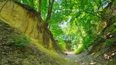
00:04:05 Łupki kambryjskie
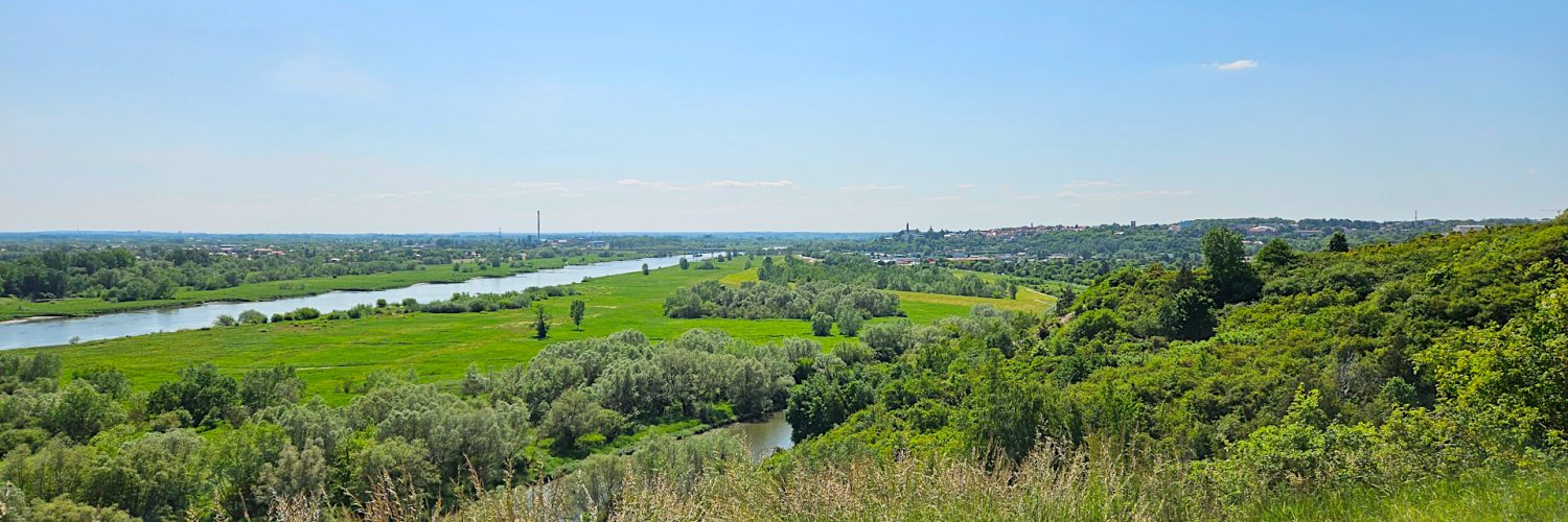
00:16:41 Starorzecze Wisły
00:17:16 Rezerwat Góry Pieprzowe
00:17:36 Łupki kambryjskie
00:18:11 Łupki kambryjskie
00:22:32 Punkt widokowy
00:50:19 Łupki kambryjskie
00:53:31 Zejście z czerwonego szlaku
00:59:13 Starorzecze Wisły
01:00:52 Łupki kambryjskie
01:05:08 Starorzecze Wisły
01:10:41 Rezerwat Góry Pieprzowe
01:15:19 Łupki kambryjskie
01:21:26 Rezerwat Góry Pieprzowe
01:23:59 Łupki kambryjskie
01:28:50 Łupki kambryjskie
01:32:07 Kamień Plebański, parking

Wyżyna Sandomierska – wschodnia część Wyżyny Kieleckiej rozciągająca się pomiędzy Górami Świętokrzyskimi na zachodzie i południowym zachodzie, Przedgórzem Iłżeckim na północy a doliną Wisły na wschodzie. Wyżynę budują skały Gór Świętokrzyskich pokryte utworami lessowymi. Jej powierzchnia jest zrównana, poprzecinana licznymi wąwozami i parowami. Oprócz tego występują tu wały lessowe, wcięcia i inne formy ukształtowania terenu. Na skałach lessowych utworzyły się żyzne czarnoziemy stanowiąc, w połączeniu z charakterystycznym mikroklimatem, idealne miejsce pod uprawę roli. O wyjątkowości mikroklimatu wyżyny może świadczyć obecność licznych gatunków kserotermicznych, które upodobały sobie sandomierskie zbocza.

Góry Pieprzowe – pagóry w południowo-wschodniej części Wyżyny Sandomierskiej nad Wisłą. Zbudowane są z łupków kambryjskich, powstałych jako osady w morzu kambryjskim ok. 500 mln lat temu a następnie uformowanych w czasie tzw. fałdowań sandomierskich około 200 mln lat temu. W dzisiejszym położeniu upad warstw sięga 90° lub nawet przekracza tę wartość, co oznacza, że ławice osadów stoją tu teraz pionowo lub są częściowo przewrócone. Łupki te rozpadają się w procesie wietrzenia w specyficzny sposób, a zwietrzelina barwą i kształtem przypomina ziarna pieprzu, co dało nazwę temu rejonowi. To za przyczyną łupków w tym miejscu pojawiły się następnie rośliny i zwierzęta, ściśle z nimi związane. Najczęściej na obrzeżach podłoże jest bogate w gliny morenowe, naniesione przez lodowiec oraz lessy, utworzone przez wiatr. Jest to wyjątkowo żyzna gleba, która jest przyczyną występowania tu tak wielu gatunków roślin. Na florę Gór Pieprzowych składa się 397 stwierdzonych dotychczas gatunków roślin naczyniowych, porostów, wątrobowców i mchów. Teren ten to przede wszystkim jedno z niewielu naturalnych i dużych „rosariów”, gdzie na niewielkim terenie rośnie kilkanaście gatunków róż. Poza różami, kwitnącymi obficie w maju i czerwcu można spotkać tu wielu przedstawicieli roślinności kserotermicznej, czyli takiej która rośnie na zboczach o wystawie południowej i zachodniej, przystosowanej do braku wody.

Film zarejestrowany w dniu 31 maja 2023 roku.

🇬🇧
Spring hiking in the Pepper Mountains in the Sandomierz Upland. From the car park in Kamień Plebański, we follow the red trail to the east, to the Pepper Mountains Reserve. Even before the reserve, at the first approach to the hill, we can admire the Cambrian shales from which the Pepper Mountains are built. During the further journey, we will come across shales a few more times. We descend the hill to the banks of the oxbow lake of the Vistula and after entering the reserve we climb another hill, on top of which there is a vantage point with a vast panorama. Then we wander along the edge of the hill admiring distant views and beautifully blooming rose bushes. At the cross, the trail turns right and, with a steep descent, we reach the oxbow lake of the Vistula again. We return to the car park along its banks, visiting the Cambrian shales hidden in the forest on the way.

🚶 Virtual hike: Walk around the Pepper Mountains, Poland
🏞️ Route: Kamień Plebański, parking (145 m a.s.l.; 50.684094, 21.778126) – Pepper Mountains Reserve (145 m a.s.l.; 50.683899, 21.783445) – Viewpoint (182 m a.s.l.; 50.684699, 21.785551) – Going off the red trail (146 m a.s.l.; 50.684910, 21.795030) – Pepper Mountains Reserve (145 m a.s.l.; 50.683899, 21.783445) – Cambrian shales (168 m a.s.l.; 50.685318, 21.783780) – Kamień Plebański, parking (145 m a.s.l.; 50.684094, 21.778126)
🆔 Trail designation: red trail, paths marked on the map
📏 Length: about 3.3 km
⏲️ Walking time: about 1:30 h
↗️ Sum of approaches: 190 m
↘️ Sum down: 190 m

00:00:22 Kamień Plebański, parking
00:04:05 Cambrian shales
00:16:41 Oxbow lake of the Vistula River
00:17:16 Pepper Mountains Reserve
00:17:36 Cambrian shales
00:18:11 Cambrian shales
00:22:32 Viewpoint
00:50:19 Cambrian shales
00:53:31 Going off the red trail
00:59:13 Oxbow lake of the Vistula River
01:00:52 Cambrian shales
01:05:08 Oxbow lake of the Vistula River
01:10:41 Pepper Mountains Reserve
01:15:19 Cambrian shales
01:21:26 Pepper Mountains Reserve
01:23:59 Cambrian shales
01:28:50 Cambrian shales
01:32:07 Kamień Plebański, parking

Sandomierz Upland – the eastern part of the Kielce Upland stretching between the Świętokrzyskie Mountains in the west and south-west, Przedgórze Iłżeckie in the north and the Vistula River valley in the east. The upland is built of rocks of the Świętokrzyskie Mountains covered with loess formations. Its surface is leveled, cut by numerous gorges and ravines. In addition, there are loess embankments, indentations and other landforms. Fertile chernozems have formed on the loess rocks, which, combined with the characteristic microclimate, is an ideal place for farming. The uniqueness of the microclimate of the upland can be evidenced by the presence of numerous xerothermic species that have taken a liking to the slopes of Sandomierz.

Pepper Mountains – hills in the south-eastern part of the Sandomierz Upland on the Vistula River. They are built of Cambrian shales, formed as sediments in the Cambrian Sea about 500 million years ago and then formed during the so-called Sandomierz folds about 200 million years ago. In today’s position, the dip of the strata reaches or even exceeds 90°, which means that the sediment beds here are now upright or partially overturned. These shales disintegrate in the process of weathering in a specific way, and the weathered rock resembles peppercorns in color and shape, which gave the region its name. It was because of the shale that plants and animals closely related to them appeared in this place. Most often, on the outskirts, the substrate is rich in moraine clays, deposited by the glacier, and loess, created by the wind. It is an exceptionally fertile soil, which is the reason why so many species of plants grow here. The flora of the Pepper Mountains consists of 397 species of vascular plants, lichens, liverworts and mosses found so far. This area is primarily one of the few natural and large „rosaria”, where over a dozen species of roses grow in a small area. In addition to roses, blooming profusely in May and June, you can meet here many representatives of xerothermic vegetation, i.e. those that grow on the slopes with southern and western exposure, adapted to the lack of water.

The film was recorded on May 31, 2023.

Region