
🇵🇱
🚶 Wirtualna wędrówka: Wejście na Krzesanicę z Doliny Kościeliskiej, Polska
🏞️ Trasa: Kościelisko, Kiry (927 m n.p.m.; 49.275497, 19.868810) – Cudakowa Polana (952 m n.p.m.; 49.264078, 19.870037) – Zahradziska (971 m n.p.m.; 49.262625, 19.871220) – Upłaziański Wierszyk (1203 m n.p.m.; 49.256322, 19.878436) – Piec (1472 m n.p.m.; 49.248643, 19.886681) – Chuda Przełączka (1851 m n.p.m.; 49.238033, 19.895609 ) – Twarda Kopa (2026 m n.p.m.; 49.248643, 19.886681) – Ciemniak (2096 m n.p.m.; 49.230995, 19.903375 ) – Mułowa Przełęcz (2067 m n.p.m.; 49.230937, 19.905792) – Krzesanica (2122 m n.p.m.; 49.231655, 19.909496)
🆔 Oznaczenie: zielony szlak, czerwony szlak
📏 Długość: około 7,0 km
⏲️ Czas przejścia: około 4:00 h
↗️ Suma podejść: 1256 m
↘️ Suma zejść: 69 m
00:00:22 Kościelisko, Kiry
00:04:48 Potok Kirowa Woda
00:05:31 Brama Kościeliska
00:05:51 Dolina Kościeliska
00:14:31 Potok Kirowa Woda
00:14:55 Cudakowa Polana
00:15:08 Potok Kirowa Woda
00:17:56 Potok Miętusi
00:18:07 Zahradziska
00:44:14 Upłaziański Wierszyk
00:57:30 Polana Rówieńki
01:17:06 Piec
01:36:42 Źródełko
02:04:49 Chuda Turnia
02:05:05 Chuda Przełączka
02:29:39 Twarda Kopa
02:41:53 Ciemniak
02:54:27 Przełęcz Mułowa
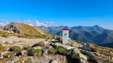
03:04:07 Krzesanica
Tatry Zachodnie (słow. Západné Tatry) – jedno z trzech pasm górskich Łańcucha Tatrzańskiego, będące zachodnią częścią Tatr, należące do Karpat, położone na granicy polsko-słowackiej. Góry graniczą z Tatrami Wysokimi na wschodzie, Podtatrzańską Kotliną na południu, Górami Choczańskimi na zachodzie i Rowem Podtatrzańskim na północy. Główny grzbiet ma 37 km długości, a pasmo górskie obejmuje 31 dwutysięczników. Tatry Zachodnie mają powierzchnię ok. 400 km², co stanowi niemal połowę całej powierzchni Tatr. 25% powierzchni Tatr Zachodnich znajduje się w Polsce, reszta na Słowacji. Są drugim pod względem wysokości pasmem górskim zarówno w Polsce, jak i na Słowacji, najwyższym szczytem jest Bystra o wysokości 2248 metrów. W polskiej części Tatr Zachodnich najwyższym szczytem jest Starorobociański Wierch (2176 m).
Trzon krystaliczny głównego grzbietu Tatr Zachodnich stanowią głębinowe skały magmowe (granity) oraz skały metamorficzne (gnejs i łupki krystaliczne, amfibolity, migmatyty, mylonity). Północne stoki Tatr Zachodnich, podobnie jak Wysokich oraz Tatry Bielskie, zbudowane są ze skał osadowych. Występowanie tutaj dużej ilości skał bardziej podatnych na erozję niż skały Tatr Wysokich jest przyczyną tego, że szczyty Tatr Zachodnich są niższe. Największy wpływ na kształtowanie rzeźby terenu wywarły wody płynące – potoki. Niewielki szlif nadały rzeźbie Tatr Zachodnich lodowce górskie. Mniejsza wysokość szczytów spowodowała, że w czasie epoki lodowcowej nie uległy one tak silnemu zlodowaceniu – powstające tutaj lodowce były mniejsze, kotły lodowcowe płytsze i nie tak surowe. Ogólnie wpływ lodowców na rzeźbę gór był tutaj mniejszy niż w Tatrach Wysokich. Wskutek występowania tutaj skał wapiennych – wapieni i dolomitów – dobrze rozwinięte są tutaj zjawiska krasowe, efektem których są liczne jaskinie i wywierzyska, żłobki krasowe, leje krasowe. Tu występuje najdłuższa i najgłębsza jaskinia Polski – Jaskinia Wielka Śnieżna.
Klimat nie różni się od klimatu w innych częściach Tatr. Najcieplejszym miesiącem jest lipiec, natomiast najzimniejszy jest luty. Na szczytach zima trwa przeciętnie od połowy października do połowy maja. Charakterystyczną cechą pogody jest duża jej zmienność, trudna do przewidzenia. W ciągu kilku godzin pogoda może się radykalnie zmienić, nie jest niczym rzadkim w lecie czy wczesną jesienią duży spadek temperatury i występowanie silnych wichur z zamieciami śnieżnymi czy gradem. Charakterystycznym rodzajem występującego w Tatrach wiatru jest halny.
Ze względu na zróżnicowanego podłoża geologicznego roślinność Tatr Zachodnich jest bogatsza i bardziej zróżnicowana gatunkowo niż w Tatrach Wysokich. Ma na to wpływ duża ilość skał wapiennych z interesującą florą roślin wapieniolubnych. Wiele gatunków roślin występuje tylko tutaj, a wiele innych, które w Tatrach Wysokich są rzadkością, tu występuje pospolicie.
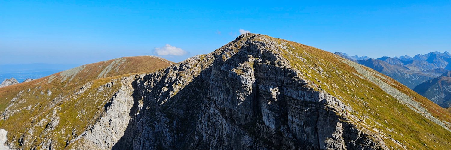
Krzesanica (Kresanica) – szczyt o wysokości 2122 m n.p.m. w grani głównej Tatr Zachodnich, najwyższy szczyt Czerwonych Wierchów. Wznosi się nad polską Doliną Miętusią i słowacką Doliną Cichą. Od wschodu sąsiaduje z Małołączniakiem (2096 m), oddzielonym od niego Litworową Przełęczą (2036 m), od zachodu z Ciemniakiem (2097 m), oddzielony Mułową Przełęczą (2067 m). Nazwa szczytu pochodzi od północnej ściany zwanej krzesaną. Szczyt Krzesanicy to niemal pozioma, kamienista platforma o długości około 100 m. Na północną stronę opada do Mułowego Kotła ścianą o wysokości około 200 m, na południe łagodnym, trawiastym zboczem.
Krzesanica zbudowana jest z dolomitów z przeławiceniami wapieni wieku środkowotriasowego i jest najwyższym polskim szczytem zbudowanym z takich skał. W pobliżu szczytu znajduje się kilka jaskiń niedostępnych dla turystów, między innymi Szczelina w Krzesanicy II, będąca najwyżej położoną jaskinią Tatr Zachodnich.
Ze szczytu roztasza się rozległa panorama na Tatry Wysokie, Tatry Zachodnie a w oddali także na Niżne Tatry, Beskid Żywiecki i Gorce.
Film zarejestrowany w dniu 27 września 2023 roku.
🇬🇧
Scenic hike in the Western Tatra Mountains. From the Kościelisko Valley we ascend the highest peak of Czerwone Wierchy – Krzesanica Mountain. Initially, the trail leads through the montane forest, gradually revealing wider views. We pass the characteristic Piec rock located at the upper edge of the forest. Then we go through a gradually disappearing dwarf pine forest and along an exposed trail we reach Chuda Przełączka, a small pass with a vast view of the Western Tatras. Then we climb along Twardy Grzbiet through Twarda Kopa to Ciemniak, the westernmost peak of Czerwone Wierchy. From Ciemniak Mountain through Mułowa Pass we ascend Krzesanica Mountain. From Krzesanica and Ciemniak there is a breathtaking view of the High Tatra Mountains, the Western Tatra Mountins and in the distance also the Low Tatra Mointains, Żywiec Beskid Mountains and the Gorce Mountains.
🚶 Virtual hike: Ascent to Krzesanica Mountain from the Kościelisko Valley, Poland
🏞️ Route: Kościelisko, Kiry (927 m a.s.l.; 49.275497, 19.868810) – Cudakowa Glade (952 m a.s.l.; 49.264078, 19.870037) – Zahradziska (971 m a.s.l.; 49.262625, 19.871220) – Upłaziański Wierszyk (1203 m a.s.l.; 49.256322, 19.878436) – Piec (1472 m a.s.l.; 49.248643, 19.886681) – Chuda Przełączka (1851 m a.s.l.; 49.238033, 19.895609) – Twarda Kopa (2026 m a.s.l.; 49.248643, 19.886681) – Ciemniak Mountain (2096 m a.s.l.; 49.230995, 19.903375) – Mułowa Pass (2067 m a.s.l.; 49.230937, 19.905792) – Krzesanica Mountain (2122 m a.s.l.; 49.231655, 19.909496)
🆔 Trail designation: green trail, red trail
📏 Length: about 7.0 km
⏲️ Walking time: about 4:00 h
↗️ Sum of approaches: 1256 m
↘️ Sum down: 69 m
00:00:22 Kościelisko, Kiry
00:04:48 Kirowa Woda Stream
00:05:31 Kościelisko Gate
00:05:51 Kościelisko Valley
00:14:31 Kirowa Woda Stream
00:14:55 Cudakowa Glade
00:15:08 Kirowa Woda Stream
00:17:56 Miętusi Stream
00:18:07 Zahradziska
00:44:14 Upłaziański Wierszyk
00:57:30 Rówieńki Glade
01:17:06 Piec
01:36:42 Spring
02:04:49 Chuda Turnia
02:05:05 Chuda Przełączka
02:29:39 Twarda Kopa
02:41:53 Ciemniak Mountain
02:54:27 Mułowa Pass
03:04:07 Krzesanica Mountain
Western Tatra Mountains – one of the three mountain ranges of the Tatra Chain, which is the western part of the Tatra Mountains, belonging to the Carpathians, located on the Polish-Slovak border. The mountains border the High Tatras in the east, the Podtatra Valley in the south, the Choč Mountains in the west and the Podtatra Trench in the north. The main ridge is 37 km long and the mountain range includes 31 two-thousanders. The Western Tatras have an area of approximately 400 km², which is almost half of the entire area of the Tatra Mountains. 25% of the area of the Western Tatras is located in Poland, the rest in Slovakia. They are the second highest mountain range in both Poland and Slovakia, the highest peak is Bystra with a height of 2,248 meters. In the Polish part of the Western Tatras, the highest peak is Starorobociański Wierch (2,176 m).
The crystalline core of the main ridge of the Western Tatras consists of deep-sea igneous rocks (granites) and metamorphic rocks (gneiss and crystalline schists, amphibolites, migmatites, mylonites). The northern slopes of the Western Tatras, like the High Tatras and the Belianske Tatras, are made of sedimentary rocks. The presence of a large amount of rocks here that are more susceptible to erosion than the rocks of the High Tatras is the reason why the peaks of the Western Tatras are lower. Flowing waters – streams – had the greatest impact on shaping the relief of the land. Mountain glaciers added a slight polish to the relief of the Western Tatras. The lower height of the peaks meant that they were not glaciated so strongly during the Ice Age – the glaciers formed here were smaller, the glacial cirques were shallower and not so severe. In general, the influence of glaciers on the relief of the mountains was smaller here than in the High Tatras. Due to the presence of limestone rocks – limestones and dolomites – karst phenomena are well developed here, resulting in numerous caves and karst valleys, karst grooves and sinkholes. The longest and deepest cave in Poland is located here – Jaskinia Wielka Śnieżna.
The climate does not differ from the climate in other parts of the Tatra Mountains. The warmest month is July, while the coldest is February. On the peaks, winter lasts on average from mid-October to mid-May. A characteristic feature of the weather is its high variability, which is difficult to predict. The weather can change radically within a few hours; in summer or early autumn, a significant drop in temperature and the occurrence of strong storms, snowstorms or hail are not uncommon. A characteristic type of wind occurring in the Tatra Mountains is mountain wind.
Due to the diverse geological substrate, the vegetation of the Western Tatras is richer and more diverse in species than in the High Tatras. This is due to the large amount of limestone rocks with an interesting flora of lime-loving plants. Many plant species are found only here, and many others that are rare in the High Tatras are common here.
Krzesanica (Kresanica) Mountain – a peak with a height of 2122 m a.s.l. on the main ridge of the Western Tatra Mountains, the highest peak of the Czerwone Wierchy. It rises above the Polish Miętusia Valley and the Slovak Cicha Valley. From the east it borders MałoŁączniak (2096 m), separated from it by Litworowa Przełęcz (2036 m), from the west it borders Ziemiak (2097 m), separated from it by Mułowa Przełęcz (2067 m). The name of the peak comes from the northern wall called Krzesana. The peak of Krzesanica is an almost horizontal, rocky platform about 100 m long. On the northern side it descends to Mułowy Kotło with a wall about 200 m high, and to the south it is a gentle, grassy slope.
Krzesanica is made of dolomites with overbanks of Middle Triassic limestone and is the highest Polish peak made of such rocks. Near the peak there are several caves inaccessible to tourists, including Szczelina w Krzesanica II, which is the highest cave in the Western Tatras.
From the top there is a vast panorama of the High Tatras, the Western Tatras and in the distance also the Low Tatra Mountains, Żywiec Beskid Mountains and the Gorce Mountains.
The film was recorded on September 27, 2023.