
🇵🇱
🚶 Wirtualna wędrówka: Wejście na Przysłopek z Kudłonia, Polska
🏞️ Trasa: Kudłoń (1274 m n.p.m.; 49.572546, 20.176005) – Polana Pustak (1236 m n.p.m.; 49.570296, 20.168312) – Polana Przysłopek (1100 m n.p.m.; 49.566538, 20.158646) – Przysłopek (1123 m n.p.m.; 49.565417, 20.152359) – Przełęcz Borek (1009 m n.p.m.; 49.559184, 20.145664) – Brukowana Droga (939 m n.p.m.; 49.570666, 20.154454) – Polana Potasznia (704 m n.p.m.; 49.578798, 20.131935) – Konina, wejście do GPN (691 m n.p.m.; 49.581398, 20.132291)
🆔 Oznaczenie: żółty szlak, czerwony szlak spacerowy
📏 Długość: około 7,6 km
⏲️ Czas przejścia: około 2:00 h
↗️ Suma podejść: 612 m
↘️ Suma zejść: 36 m
00:00:22 Kudłoń
00:02:16 Skrzyżowanie czarnego, zielonego i żółtego szlaku
00:11:49 Polana Pustak
00:15:00 Skrzyżowanie czarnego i żółtego szlaku
00:26:57 Polana Przysłopek
00:32:39 Zejście ze szlaku
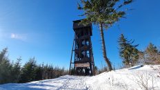
00:39:13 Przysłopek
00:44:15 Powrót na żółty szlak
00:56:37 Przełęcz Borek
01:20:23 Potok
01:21:00 Brukowana Droga
01:33:54 Potok
01:41:34 Potok
01:45:03 Potok
01:49:31 Potok Konina
01:50:08 Polana Potasznia
01:55:43 Konina, wejście do GPN
Gorce – pasmo górskie należące do Beskidów Zachodnich. Położone jest miedzy dolinami rzek Raba i Dunajec. Na północy graniczy z Beskidem Wyspowym, a na południu z Podhalem. Krajobraz Gorców stanowią rozchodzące się promieniście różnej długości grzbiety rozdzielone głęboko wciętymi dolinami o stromych zboczach. Szczególną wartość dla krajobrazu i przyrody Gorców mają polany reglowe. Powstały w wyniku tradycyjnej gospodarki pasterskiej. Znajdują się na nich liczne drewniane szałasy pasterskie reprezentujące regionalne budownictwo zagórzańskie i podhalańskie. Utworzony w 1981 roku Gorczański Park Narodowy chroni centralną część Gorców, obejmuje najmniej zmienione przez człowieka dolnoreglowe lasy mieszane, zwane buczyną karpacką.
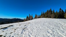
Przysłopek – szczyt o wysokości 1123 m n.p.m. w Gorcach. Znajduje się w grzbiecie pomiędzy Kudłoniem a Przełęczą Borek. Jego południowy stok opada do doliny Kamienicy, zachodni do jej dopływu, potoku Kania, północno-wschodni do doliny potoku Konina. Po wschodniej stronie szczytu znajduje się Polana Przysłopek, przez którą prowadzi szlak turystyczny.
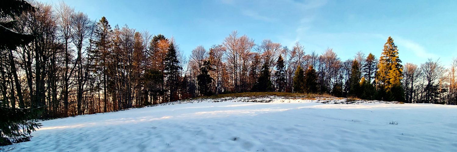
Polana Przysłopek – nieduża polana i w Gorcach znajdująca się na grzbiecie łączącym Przysłopek (1123 m) z Kudłoniem (1276 m). Zajmuje wschodnie, podwierzchołkowe zbocza Przysłopka i grzbiet przełęczy pomiędzy Przysłopkiem i Kudłoniem. Była intensywnie wypasana jeszcze w latach 80. przez mieszkańców Koniny i znajdowały się na niej 2 szopy. Po włączeniu tego obszaru do Gorczańskiego Parku Narodowego zniesiono wypas i polana zaczyna zarastać. Można tutaj obserwować kolejne etapy naturalnej sukcesji ekologicznej. Na znacznej części polany pojawiły się już młode świerki. W 2021 roku polana jednak jest znowu koszona.
Film zarejestrowany w dniu 3 grudnia 2022 roku.
🇬🇧
The second part of the autumn-winter hike in the Gorce Mountains. From Kudłoń Mountain we go down to the beautiful Pustak Glade with a vast view of the Gorce and Tatra Mountains. Further along the yellow trail, we descend to the Przysłopek Glade, from which we climb a short ascent to the peak of the same name. After returning to the trail, we reach the Borek Pass, where the trails intersect. Following the red walking trail, leading along the former Paved Road, we descend to Polana Potasznia and to the parking lot at the border of the Gorce National Park.
🚶 Virtual hike: Ascent to Przysłopek Mountain from Kudłoń Mountain, Poland
🏞️ Route: Kudłoń Mountain (1274 m a.s.l.; 49.572546, 20.176005) – Pustak Glade (1236 m a.s.l.; 49.570296, 20.168312) – Przysłopek Glade (1100 m a.s.l.; 49.566538, 20.158646) – Przysłopek Mountain (1123 m a.s.l.; 49.565417, 20.152359) – Borek Pass (1009 m a.s.l.; 49.559184, 20.145664) – Brukowana Droga (939 m a.s.l.; 49.570666, 20.154454) – Potasznia Glade (704 m a.s.l.; 49.578798, 20.131935) – Konina, entrance to the GNP (691 m a.s.l.; 49.581398, 20.132291)
🆔 Trail designation: yellow trail, red walking trail
📏 Length: about 7.6 km
⏲️ Walking time: about 2:00 h
↗️ Sum of approaches: 612 m
↘️ Sum down: 36 m
00:00:22 Kudłoń Mountain
00:02:16 Crossing of the black, the yellow and the green trails
00:11:49 Pustak Glade
00:15:00 Crossing of the black trail and the yellow trail
00:26:57 Przysłopek Glade
00:32:39 Going off the trail
00:39:13 Przysłopek Mountain
00:44:15 Return to the yellow trail
00:56:37 Borek Pass
01:20:23 Stream
01:21:00 Brukowana Droga
01:33:54 Stream
01:41:34 Stream
01:45:03 Stream
01:49:31 Konina Stream
01:50:08 Potasznia Glade
01:55:43 Konina, entrance to the GNP
Gorce Mountains – a mountain range belonging to the Western Beskids. It is situated between the valleys of the rivers Raba and Dunajec. It borders with Beskid Wyspowy in the north and Podhale in the south. The landscape of the Gorce Mountains consists of radially diverging ridges of various lengths separated by deeply cut valleys with steep slopes. The mountain clearings are of particular value for the landscape and nature of the Gorce Mountains. They were created as a result of the traditional pastoral economy. There are numerous wooden shepherd’s huts representing the regional architecture of Zagórze and Podhale. Created in 1981, the Gorce National Park protects the central part of the Gorce Mountains, and includes the least changed by man mixed forests, known as the Carpathian beech forest.
Przysłopek Mountain– a peak with a height of 1123 m a.s.l. in Gorce. It is located on the ridge between Kudłoń and the Borek Pass. Its southern slope descends to the Kamienica valley, the western one to its tributary, the Kania stream, and the north-eastern one to the Konina stream valley. On the eastern side of the peak there is the Przysłopek Glade, through which a tourist trail leads.
Przysłopek Glade – a small glade in the Gorce Mountains located on the ridge connecting Przysłopek (1123 m) with Kudłoń (1276 m). It occupies the eastern, sub-peak slopes of Przysłopek and the ridge of the pass between Przysłopek and Kudłoń. It was intensively grazed by the inhabitants of Konina in the 1980s and there were 2 sheds on it. After incorporating this area into the Gorce National Park, grazing was abolished and the glade began to overgrow. Here you can observe successive stages of natural ecological succession. Young spruces have already appeared on a large part of the clearing. In 2021, however, the glade is mowed again.
The film was recorded on December 3, 2022.