Jesienna wędrówka po Masywie Ślęży. Z Przełęczy Tąpadła wchodzimy na Ślężę, najwyższy szczyt masywu. Zielonym szlakiem dochodzimy do Ścieżki przyrodniczej "Skalna", która malowniczym gołoborzem prowadzi do punktu widokowego Skalne Capki. Roztacza się stąd rozległy widok na Góry Sowie i Góry Wałbrzyskie. Dalej ścieżką przyrodniczą dochodzimy na szczyt Skalne. Za szczytem wchodzimy na niebieski szlak, którym przez piękną Skalną Perć i dochodzimy na kolejny punkt widokowy. Następnie wchodzimy na szczyt Ślęży, na którym znajduje się wieża widokowa z fantastycznym widokiem na Sudety i Przedgórze Sudeckie.

🇵🇱
🚶 Wirtualna wędrówka: Wejście na Ślężę z Przełęczy Tąpadła, Polska
🏞️ Trasa: Przełęcz Tąpadła (379 m n.p.m.; 50.845785, 16.699047) – Ścieżka przyrodnicza „Skalna” (399 m n.p.m.; 50.857498, 16.683567) – Punkt widokowy Skalne Capki (487 m n.p.m.; 50.857252, 16.686752) – Skalne (522 m n.p.m.; 50.857994, 16.688350) – Żródełko Jurkl Quelle (521 m n.p.m.; 50.862934, 16.692368) – Skalna Perć (587 m n.p.m.; 50.865111, 16.695399) – Punkt widokowy nad Skalną Percią (650 m n.p.m.; 50.864028, 16.699476) – Ślęża (718 m n.p.m.; 50.864055, 16.707442) – Kościół Nawiedzenia Najświętszej Maryi Panny na Ślęży (708 m n.p.m.; 50.865026, 16.708129)
🆔 Oznaczenie: niebieski szlak, zielony szlak, zielona ścieżka przyrodnicza
📏 Długość: około 5,0 km
⏲️ Czas przejścia: około 2:00 h
↗️ Suma podejść: 384 m
↘️ Suma zejść: 56 m

00:00:29 Przełęcz Tąpadła
00:02:42 Skrzyżowanie niebieskiego, zielonego, żółtego i czarnego szlaku
00:04:01 Skrzyżowanie niebieskiego, zielonego i żółtego szlaku
00:17:08 Skrzyżowanie zielonego i niebieskiego szlaku
00:20:45 Ścieżka przyrodnicza „Skalna”
00:32:32 Punkt widokowy Skalne Capki
00:41:52 Skalne
00:46:25 Skrzyżowanie zielonej ścieżki przyrodniczej, szlaku spacerowego czarnego i niebieskiego szlaku
00:49:31 Skrzyżowanie szlaku spacerowego czarnego i niebieskiego szlaku
00:53:28 Skrzyżowanie szlaku spacerowego czarnego i niebieskiego szlaku
00:56:42 Źródełko Jurkl Quelle
01:08:39 Skalna Perć
01:25:19 Punkt widokowy nad Skalną Percią
01:40:23 Ślęża
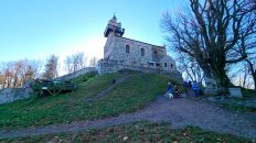
01:45:38 Kościół Nawiedzenia Najświętszej Maryi Panny na Ślęży

Masyw Ślęży – mezoregion fizycznogeograficzny będący najbardziej na północ wysuniętym fragmentem Przedgórza Sudeckiego. Masyw Ślęży od północy graniczy z Równiną Kącką, od wschodu i południowego wschodu ze Wzgórzami Niemczańsko-Strzelińskimi, od południa z Obniżeniem Podsudeckim i od zachodu z Równiną Świdnicką. Najwyższym szczytem jest Ślęża (718 m n.p.m.) będąca jednocześnie najwyższym wzniesieniem Przedgórza Sudeckiego.
Partie szczytowe, południowy i wschodni stok Ślęży zbudowane są z najstarszych skał masywu – z ciemnozielone gabra. Północna część masywu w rejonie Wieżycy, Gozdnicy i Stolnej zbudowana jest z amfibolitów, a część południowa – masyw Raduni, Wzgórza Oleszeńskie i Wzgórza Kiełczyńskie – z serpentynitów. W czasie orogenezy hercyńskiej wykrystalizowały się jasnoszare granity, budujące północno-zachodnie zbocza Ślęży.
W plejstocenie w erze kenozoicznej Masyw Ślęży był dwukrotnie ogarnięty lądolodem skandynawskim, w zlodowaceniu południowopolskim (przed 480–430 tysiącami lat) i środkowopolskim (przed 240–180 tysiącami lat). Szczyt wystawał nad powierzchnię lodowca tylko około 100 m, w formie nunataka. Surowy klimat doprowadził do potrzaskania odsłoniętej skały i utworzenia wokół szczytu gołoborzy, obecnie porośniętych lasem. W trakcie topnienia lodu na spłaszczeniach pod szczytem pozostały czapy moreny, a na stokach terasy kemowe, utworzone z piasku składanego przez spływające wody. U podnóża pozostały po ustąpieniu lodowca gliniaste osady moreny dennej, która zrównała dawniejsze zaklęsłości i przykryła grubym płaszczem starsze osady.
Roślinność porastająca masyw należy do regla dolnego. W drzewostanie lasu przeważają świerki. Dużo jest drzew liściastych, głównie dębów i buków podchodzących pod sam bezleśny szczyt. Lokalnie rosną stare jawory, szczególnie dużo na Ślęży, las sosnowo-dębowy na Raduni, zaś na Wieżycy – lipy i jarzęby brekinie, a także fragment starego bukowego lasu. W niższych partiach występują sporadycznie różnogatunkowe grądy, natomiast wzdłuż strumieni kępy olch i jesionów, tworzących zbiorowiska łęgowe oraz unikalne zespoły bagienno-torfowiskowe.

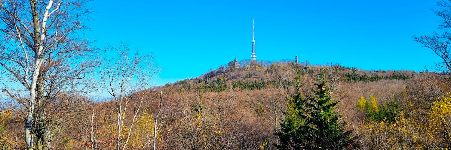
Ślęża – najwyższy szczyt Masywu Ślęży i całego Przedgórza Sudeckiego o wysokość 718 m n.p.m. Wysokość względna wynosi ponad 500 m. Ślęża zbudowana jest głównie z granitów i gabra. Gabra tworzą szczyt Ślęży i jej południowe oraz wschodnie stoki, serpentynity odsłaniają się na Raduni i wzgórzach położonych na wschód i zachód od niej, natomiast amfibolity są znane z Wieżycy i Gozdnicy – niewielkich szczytów w północnej części Masywu Ślęży koło Sobótki.
Ślęża porośnięta jest lasem mieszanym z przewagą świerka. Szczyt jest bezleśny, na którym znajduje się Kościół pod wezwaniem Nawiedzenia NMP, Dom Turysty PTTK na Ślęży, Radiowo-Telewizyjne Centrum Nadawcze Ślęża a na samym wierzchołku wieża widokowa.

Film zarejestrowany w dniu 6 listopada 2022 roku.

🇬🇧
Autumn hiking on the Ślęża Massif. From the Tąpada Pass we climb Ślęża, the highest peak of the massif. Following the green trail, we reach the „Skalna” nature trail, which leads along a picturesque stone run to the Skalne Capki viewpoint. There is a vast view of the Sowie Mountains and the Wałbrzych Mountains from here. Further along the nature trail we reach the top of Skalne. Behind the peak, we enter the blue trail and through the beautiful Skalna Perć reach the viewpoint. Then we go to the top of Ślęża, where there is an observation tower with a fantastic view of the Sudety Mountains and the Sudety Foothills.

🚶 Virtual hike: Ascent to Ślęża Mountain from Tąpadła Pass, Poland
🏞️ Route: Tąpadła Pass (379 m a.s.l.; 50.845785, 16.699047) – „Skalna” nature trail (399 m a.s.l.; 50.857498, 16.683567) – Skalne Capki viewpoint (487 m a.s.l.; 50.857252, 16.686752) – Skalne (522 m a.s.l.; 50.857994, 16.688350) – Jurkl Quelle Spring (521 m a.s.l.; 50.862934, 16.692368) – Skalna Mountain Path (587 m a.s.l.; 50.865111, 16.695399) – Viewpoint at Skalna Mountain Path (650 m a.s.l.; 50.864028, 16.699476) – Ślęża (718 m a.s.l.; 50.864055, 16.707442) – The Church of the Visitation of the Blessed Virgin Mary on Ślęża (708 m a.s.l.; 50.865026, 16.708129)
🆔 Trail designation: blue trail, green trail, green nature trail
📏 Length: about 5.0 km
⏲️ Walking time: about 2:00 h
↗️ Sum of approaches: 384 m
↘️ Sum down: 56 m

00:00:29 Tąpadła Pass
00:02:42 Crossing of the blue, the green, the yellow and the black trails
00:04:01 Crossing of the blue, the green and the yellow trails
00:17:08 Crossing of the green and the blue trails
00:20:45 „Skalna” nature trail
00:32:32 Skalne Capki viewpoint
00:41:52 Skalne
00:46:25 Crossing of the green nature trail, the black walking trail and the blue trail
00:49:31 Crossing of the black walking trail and the blue trail
00:53:28 Crossing of the black walking trail and the blue trail
00:56:42 Jurkl Quelle Spring
01:08:39 Skalna Mountain Path
01:25:19 Viewpoint at Skalna Mountain Path
01:40:23 Ślęża
01:45:38 The Church of the Visitation of the Blessed Virgin Mary on Ślęża

The Ślęża Massif – a physico-geographical mesoregion which is the northernmost part of the Sudety Foreland. The Ślęża Massif borders the Kącka Plain from the north, the Niemczańsko-Strzeliński Hills from the east and south-east, the Sudety Foreland Depression from the south and the Świdnicka Plain from the west. The highest peak is Ślęża (718 m above sea level), which is also the highest hill of the Sudety Foreland.
The top parts, the southern and eastern slopes of Ślęża are built of the oldest rocks of the massif – dark green gabbros. The northern part of the massif in the area of Wieżyca, Gozdnica and Stolna is built of amphibolites, and the southern part – the Radunia massif, Oleszeńskie Hills and Kiełczyńskie Hills – of serpentines. During the Hercynian orogeny, light gray granites crystallized, building the north-western slopes of Ślęża.
In the Pleistocene, in the Cenozoic Era, the Ślęża Massif was covered twice by the Scandinavian ice sheet, in the South Polish Glaciation (480-430 thousand years ago) and the Central Polish Glaciation (240-180 thousand years ago). The peak protruded above the surface of the glacier only about 100 m, in the form of nunataka. The harsh climate led to the shattering of the exposed rock and the creation of boulder fields around the top, now covered with forest. During the melting of the ice, moraine caps remained on the flats below the summit, and kame terraces on the slopes, formed of sand deposited by flowing water. At the foot of the glacier, clay deposits of the ground moraine remained after the glacier retreated, which leveled the former depressions and covered the older settlements with a thick mantle.
The vegetation covering the massif belongs to the lower montane zone. The forest stand is dominated by spruces. There are many deciduous trees, mainly oaks and beeches reaching the very forestless peak. Old sycamores grow locally, especially in Ślęża, a pine and oak forest on Radunia, and in Wieżyca – lime trees and rowans, wild service trees, as well as a fragment of an old beech forest. In the lower parts, there are sporadic oak-hornbeam forests of various species, while along the streams there are clumps of alders and ashes, forming riparian communities and unique swamp and peat bog complexes.

Ślęża – the highest peak of the Ślęża Massif and the entire Sudety Foothills, 718 m a.s.l. The relative height is over 500 m. Ślęża is built mainly of granite and gabro. Gabra form the peak of Ślęża and its southern and eastern slopes, serpentines are exposed on Radunia and the hills to the east and west of it, while amphibolites are known from Wieżyca and Gozdnica – small peaks in the northern part of the Ślęża Massif near Sobótka.
Ślęża is covered with a mixed forest with a predominance of spruce. The peak is forestless, with the Church of the Visitation of the Blessed Virgin Mary, the PTTK Tourist House in Ślęża, the Ślęża Radio and Television Broadcasting Center and the observation tower at the very top.

The film was recorded on November 6, 2022.

Region