
🇵🇱
🚶 Wirtualna wędrówka: Zejście ze Smerekowej przez Jaworzynę do Jaworek, Polska
🏞️ Trasa: Smerekowa (1014 m n.p.m.; 49.375419, 20.577017) – Jaworzyna (1016 m n.p.m.; 49.377116, 20.571901) – Uroczysko Zaskalskie (910 m n.p.m.; 49.380145, 20.570086) – Skalski Potok (727 m n.p.m.; 49.388107, 20.568209) – Dolna stacja kolei linowej „Homole” (603 m n.p.m.; 49.402743, 20.560055)
🆔 Oznaczenie: niebieski szlak, drogi i ścieżki oznaczone i nieoznaczone na mapie
📏 Długość: około 5,6 km
⏲️ Czas przejścia: około 2:20 h
↗️ Suma podejść: 46 m
↘️ Suma zejść: 445 m
00:00:22 Smerekowa
00:10:20 Niebieski szlak
00:17:37 Zejście ze szlaku
00:21:32 Jaworzyna Góra
00:28:10 Powrót na niebieski szlak
00:43:29 Zejście ze szlaku
00:47:11 Skalski Potok
00:53:54 Uroczysko Zaskalskie
01:27:03 Skalski Potok
01:44:19 Rezerwat Przyrody Zaskalskie-Bodnarówka
02:11:03 Dolna stacja kolejki linowej Homole
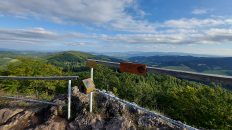
Pieniny – pasmo górskie położone w południowej Polsce i północnej Słowacji. Od południa Pieniny graniczą z pasmem Magury Spiskiej, od północy z Gorcami i Beskidem Sądeckim, na zachodzie zaś – z Kotliną Orawsko-Nowotarską oraz Pogórzem Spisko-Gubałowskim. Dzielą się na trzy części: Pieniny Spiskie, Pieniny Właściwe i Małe Pieniny. Najwyższe szczyty to Wysoka (1050 m), Jaworzyna (1016 m), Smerekowa (1014 m).
Skały budujące Pieniny powstały na dnie mórz w kilku epokach geologicznych. W górnej kredzie zostały sfałdowane i wydźwignięte. Na początku trzeciorzędu nastąpiła druga fala ruchów tektonicznych powodująca kolejne przesunięcia płaszczowin. Trzecia fala ruchów górotwórczych w okresie paleogenu i neogenu spowodowała powstanie bardzo skomplikowanej struktury tektonicznej pasa skałkowego. Równocześnie zachodząca erozja zdarła zewnętrzny płaszcz skał i wymodelowała skomplikowaną rzeźbę terenu. Szczyty i turnie zbudowane są z odpornych na wietrzenie skał jurajskich, głównie wapieni rogowcowych, bulastych i krynoidowych. Doliny i przełęcze powstały w miękkich i podatnych na wietrzenie skałach z okresu kredy i paleogenu.
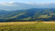
Krajobraz Pienin tworzą strzeliste szczyty i głęboko wcięte wąwozy porozdzielane rozległymi halami pasterskimi.
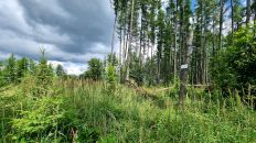
Jaworzyna – szczyt o wysokości 1016 m n.p.m. w Pieninach. Jest drugim co do wysokości szczytem w polskiej części Pienin. Jaworzyna znajduje się w głównej grani Małych Pienin pomiędzy Smerekową (1014 m) na wschodzie i Wysoką (1050 m) na zachodzie. Przez szczyt przebiega polsko-słowacja granica.
Wirzchołek jest całkowicie zalesiony, z daleka widoczny jest jedynie jako niewybitne uwypuklenie zbocza Smerekowej, co jednak jest pozorne, gdyż wśród drzew ukryta jest wysoka na kilkanaście metrów wapienna skała. Na większości map turystycznych Jaworzyna nie jest nanoszona.
Smerekowa (Vysoká) – szczyt o wysokości 1014 m n.p.m. w Pieninach. Jest trzecim co do wysokości szczytem tego pasma górskiego. Znajduje się w grzbiecie głównym Małych Pienin pomiędzy Jaworzyną a Watriskiem. Jest mało wybitnym, słabo wyróżniającym się szczytem. Położony jest po stronie słowackiej, stoki po polskiej stronie osiągają 1004 m. Po połnocnej stronie wierzchołka znajduje się niewielka polana z widokiem na Beskid Sądecki, partie wierzchołkowe po południowej stronie są porośnięte lasem.
Pod szczytem Smerekowej bieże początek płynący w Polsce i znajdujący się w zlewni Dunajca Skalski Potok. Po słowackiej stronie w stokach Smerekowej mają jeszcze źródła potoki zasilające Kamienkę i jej dopływ Riečkę. Obydwa te potoki znajdują się w zlewni Popradu.
Film zarejestrowany w dniu 2 sierpnia 2023 roku.
🇬🇧
The second part of the summer hike in the Pieniny Mountains. We descend from Smerekowa, the third highest peak of the Pieniny Mountains, and ascend Jaworzyna, the second highest peak of this mountain range. There is no path leading to the peak and it is not marked on maps. Then we descend along roads and paths without a trail to the Skalski Stream Valley. We pass through the Zaskalskie-Bodnarówka Reserve on the water, along the Skalski Stream bed. We end the hike at the Homole Cable Car station.
🚶 Virtual hike: Descent from Smerekowa through Jaworzyna to Jaworki, Poland
🏞️ Route: Smerekowa Mountain (1014 m a.s.l.; 49.375419, 20.577017) – Jaworzyna Mountain (1016 m a.s.l.; 49.377116, 20.571901) – Uroczysko Zaskalskie (910 m a.s.l.; 49.380145, 20.570086) – Skalski Stream (727 m a.s.l.; 49.388107, 20.568209) – Lower station of the Homole cable car (603 m a.s.l.; 49.402743, 20.560055)
🆔 Trail designation: blue trail, roads and paths marked and unmarked on the map
📏 Length: about 6.9 km
⏲️ Walking time: about 2:30 h
↗️ Sum of approaches: 497 m
↘️ Sum down: 85 m
00:00:22 Smerekowa Mountain
00:10:20 Blue trail
00:17:37 Going off the trail
00:21:32 Jaworzyna Mountain
00:28:10 Return to the blue trail
00:43:29 Going off the trail
00:47:11 Skalski Stream
00:53:54 Uroczysko Zaskalskie
01:27:03 Skalski Stream
01:44:19 Zaskalskie-Bodnarówka Reserve
02:11:03 Lower station of the Homole cable car
Pieniny Mountains – a mountain range located in southern Poland and northern Slovakia. In the south, the Pieniny Mountains border on the Spišská Magura range, in the north with the Gorce Mountains and Sącz Beskid Mountains, and in the west with the Orawa-Nowy Targ Valley and the Spiš-Gubałowskie Foothills. They are divided into three parts: Pieniny Spiskie, Pieniny Proper and Małe Pieniny. The highest peaks are Wysoka (1050 m), Jaworzyna (1016 m), Smerekowa (1014 m).
The rocks that make up the Pieniny Mountains were formed at the bottom of the seas in several geological eras. In the Upper Cretaceous they were folded and uplifted. At the beginning of the Tertiary, there was a second wave of tectonic movements causing further shifts of the nappes. The third wave of orogenic movements in the Paleogene and Neogene periods resulted in the formation of a very complicated tectonic structure of the rock belt. At the same time, the erosion that took place at the same time removed the outer mantle of rocks and created a complex relief. The peaks and crags are made of weathering-resistant Jurassic rocks, mainly hornstone, bulbous and crinoid limestones. The valleys and passes were formed in soft and weathering rocks from the Cretaceous and Paleogene periods.
The landscape of the Pieniny Mountains is made up of soaring peaks and deeply cut gorges divided by vast shepherd’s pastures.
Jaworzyna – a peak with a height of 1,016 m above sea level. in the Pieniny Mountains. It is the second highest peak in the Polish part of the Pieniny Mountains. Jaworzyna is located on the main ridge of the Małe Pieniny Mountains between Smerekowa (1014 m) in the east and Wysoka (1050 m) in the west. The Polish-Slovak border runs through the peak.
The peak is completely forested, and from a distance it is visible only as an inconspicuous bulge on the slope of Smerekowa, which, however, is only apparent because a limestone rock several meters high is hidden among the trees. Jaworzyna is not marked on most tourist maps.
Smerekowa (Vysoká) – a peak with a height of 1014 m a.s.l. in the Pieniny Mountains. It is the third highest peak of this mountain range. It is located in the main ridge of the Małe Pieniny Mountains between Jaworzyna and Watrisk. It is an unremarkable, poorly distinguished peak. It is located on the Slovak side, the slopes on the Polish side reach 1,004 m. On the northern side of the peak there is a small clearing with a view of the Sącz Beskid Mountains, the peak parts on the southern side are covered with forest.
Below the peak of Smerekowa there is the beginning of the Skalski Potok flowing in Poland and located in the Dunajec catchment area. On the Slovak side, in the slopes of Smerekova, there are streams feeding the Kamienko and its tributary Riečka. Both of these streams are located in the Poprad catchment area.
The film was recorded on August 2, 2023.