
🇵🇱
🚶 Wirtualna wędrówka: Wejście na Baranie z Olchowca, Polska
🏞️ Trasa: Olchowiec (428 m n.p.m.; 49.472515, 21.603417) – Magurski Park Narodowy (499 m n.p.m.; 49.453703, 21.609402) – Przełęcz Szarbowska (550 m n.p.m.; 49.444936, 21.615025) – Sedlo pod Stavkom (656 m n.p.m.; 49.437827, 21.606465) – Baranie (754 m n.p.m.; 49.436779, 21.597617)
🆔 Oznaczenie: Ścieżka przyrodniczo-historyczna „Olchowiec”, żółty szlak
📏 Długość: około 5,4 km
⏲️ Czas przejścia: około 1:40 h
↗️ Suma podejść: 340 m
↘️ Suma zejść: 18 m
00:00:22 Olchowiec
00:00:33 Potok Wilsznia
00:01:01 Cerkiew Przeniesienia Relikwii św. Mikołaja w Olchowcu
00:01:16 Kamienny most z XVI w.
00:05:56 Potok Olchowczyk
00:07:31 Potok Olchowczyk
00:10:29 Potok Olchowczyk
00:17:00 Potok Olchowczyk
00:31:34 Potok
00:32:19 Magurski Park Narodowy
00:45:19 Potok
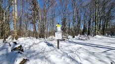
00:51:39 Przełęcz Szarbowska
01:09:41 Sedlo pod Stavkom
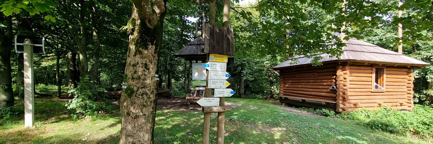
01:24:22 Baranie
Beskid Niski – pasmo górskie w Karpatach między przełęczami Łupkowską na wschodzie a Tylicką na zachodzie. Wschodnia granica Beskidu Niskiego jest zarazem granicą Karpat Wschodnich i Zachodnich. Od wschodu graniczy z Bieszczadami, od północnego wschodu z Pogórzem Bukowskim, od zachodu z Kotliną Sądecką, od południowego zachodu z Beskidem Sądeckim, a od północy z Pogórzem Środkowobeskidzkim.
Najwyższy szczyt po polskiej stronie to Lackowa (997 m n.p.m.), a po słowackiej Busov (1002 m n.p.m.), który jako jedyny przekracza 1000 m. Ważniejsze rzeki to Osławica, Wisłok, Jasiołka, Wisłoka, Ropa i Biała Dunajcowa, należą do zlewni Morza Bałtyckiego.
W centrum Beskidu Niskiego znajduje się Magurski Park Narodowy, a we wschodniej części Jaśliski Park Krajobrazowy. Beskid Niski jest najniższą a zarazem najrozleglejszą częścią Beskidów i całego łuku Karpat.
Beskid Niski dzieli się na: Góry Grybowskie, Góry Hańczowskie, Beskid Gorlicki, Pasmo Magurskie, Beskid Dukielski, Pasmo Bukowicy i Kamienia, Gniazdo Jawornika, Pasmo graniczne, Wzgórza Rymanowskie.
Beskid Niski zbudowany jest ze skał osadowych zwanych fliszem karpackim. Są to najczęściej naprzemiennie ułożone ławice zlepieńców, piaskowców i łupków ilastych. Najniższa jest płaszczowina śląska, środkowa – dukielska, a najwyższa – magurska. Wychodnie piaskowców magurskich często mają postać fantastycznych form skalnych. Najbardziej znane są Kornuty na Magurze Wątkowskiej i Diabli Kamień koło Folusza. Występuje też wiele jaskiń. Największe ich skupiska to Kilanowska Góra k. Lipowicy (około 70 jaskiń) oraz Cergowa (11 jaskiń). Znana jest Jaskinia Mroczna w Kornutach, której łączna długość korytarzy sięga prawie 200 m, a głębokość 15,5 metrów.
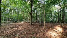
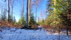
W Beskidzie Niskim występują tylko dwa piętra roślinne: pogórza (do 550 m n.p.m.) i regiel dolny. Piętro pogórza tworzą pozostałości pierwotnych lasów dębowo – grabowych, olszy i zarośla wikliny w dolinach rzek, natomiast regiel dolny to lasy jodłowe, bukowe i sosnowe. Szczególnie liczne są drzewostany bukowe, a świerk jest niemal nieobecny.
Baranie / Stávok – szczyt o wysokości 754 m n.p.m. w Beskidzie Niskim, w paśmie Beskidu Dukielskiego. Masyw Baraniego ma postać dziesięciokilometrowej długości grzbietu, przebiegającego z północnego zachodu na południowy wschód. Jego południowa część znajduje się po słowackiej stronie. Na północ grzbiet stopniowo opada ku zbiegowi dolin Wilszni i Hucianki, tworząc kilka mało wybitnych kumulacji. Niegdyś najwyższą część masywu po stronie polskiej nazywano Jaworyskami. Grzbiet Baraniego jest typowy dla tej części Beskidu Niskiego – szeroki i zaokrąglony, przechodzi w stoki o nachyleniu do 20°. W ich obrębie brak jest większych form osuwiskowych, tak charakterystycznych dla innych części Beskidów.
Taki układ grzbietu ma ścisły związek z budową geologiczną. Jest on założony na piaskowcach magurskich – odpornej skale osadowej, powstałej w Oceanie Tetydy poprzez scementowanie piasków o różnej grubości ziaren. Piaskowiec magurski ma barwę szarą i tworzy grube ławice, poprzetykane cienkimi warstewkami łupków ilastych. Skały te uległy sedymentacji na początku oligocenu, ok. 30 mln lat temu. Powyżej piaskowców magurskich zalegają nieco młodsze warstwy nadmagurskie, a poniżej – starsze warstwy podmagurskie. Zawierają one więcej łupków i wskutek tego cechują się mniejszą odpornością. Jeszcze niżej znajdują się czerwonawej barwy łupki pstre oraz warstwy ropianieckie, po raz pierwszy opisane w niedalekiej Ropiance (stąd nazwa). Cały ten przekładaniec skał osadowych nosi nazwę fliszu karpackiego, a w występującej tutaj sekwencji – serii magurskiej.
Seria ta buduje płaszczowinę magurską – jedną z głównych struktur geologicznych Karpat Zewnętrznych. Płaszczowina składa się zazwyczaj z szeregu fałdów – tutaj jednak jest inaczej. Zamiast pofałdowania, w czasie alpejskich ruchów górotwórczych doszło do porozrywania górotworu, którego fragmenty ponasuwały się na siebie, tworząc tzw. łuski. Strefy nasunięć tektonicznych, ograniczających łuskę góry Baranie, przebiegają północno-zachodnimi stokami masywu oraz na zachód od doliny potoku Baranie. W ich rejonie występują mało odporne pstre łupki, przez co mamy tu spłaszczenia oraz źródliska (łupki są skałami nieprzepuszczalnymi). Skały zapadają ogólnie w południowo-zachodnim, wskutek czego grzbiet Baraniego ma charakter monokliny. Dzięki występowaniu łusek o mniej-więcej równoległych granicach nasunięć, również i grzbiety są na tym obszarze równoległe. Taki ich układ nazywamy rusztowym. Jest on charakterystyczny dla Beskidu Niskiego, części Bieszczadów czy Pogórza Przemyskiego. Lokalne uskoki wyznaczają bieg niewielkich cieków, a w przypadku większych dolin warunkują istnienie odcinków przełomowych.
W czasie ruchów górotwórczych dochodziło do przestojów, w czasie których powstający górotwór ulegał niszczeniu i wyrównaniu. Gdy dochodziło do kolejnej fazy ruchów wznoszących, wyrównana powierzchnia ulegała wydźwignięciu i była rozcinana przez cieki. Powstały w ten sposób tzw. poziomy zrównania. Na Baranim wyróżnić można dwa z nich – wyższy wznosi się ok. 200 m ponad otaczające doliny i jest reprezentowany przez grzbiet główny, niższy (młodszy) tworzą grzbiety o wysokości względnej ok. 120 m. Są to m.in. boczne grzbiety Baraniego: Czoło, Horbek czy Rubań oraz położone po przeciwnej stronie Olchowca Kury Wierch, Dił i Kyjasz.
Choć dziś trudno w to uwierzyć, w przeszłości grzbiet był w dużej mierze wylesiony. Jedynie sam wierzchołek oraz stoki opadające do doliny potoku Baranie porastał las. Wysoki i centralnie położony w Beskidzie Niskim szczyt stanowił wtenczas znakomity punkt widokowy, tym bardziej że stała na nim stalowa wieża triangulacyjna, zbudowana przez Niemców w latach II wojny światowej (zawaliła się zimą 1999/2000). Panorama z niej obejmowała cały Beskid Niski, a także m.in. Tatry, Bieszczady i Połoninę Równą. W 2006 r. Słowacy wybudowali drewnianą wieżę widokową, która z uwagi na zły stan techniczny została podcięta pod koniec kwietnia 2019 roku.
Film zarejestrowany w dniu 1 września 2023 roku.
🇬🇧
Summer hike along the „Olchowiec” nature and historical trail in the Low Beskid Mountains. The trail starts in Olchowiec and leads through the picturesque valley of the Olchowczyk stream. After entering the Magura National Park, we take a gentle approach to the Szarbowska Pass. The nature trail and the yellow trail connect here with the Slovak red trail called the Eastern Carpathian Main Trail and the blue trail named after Kazimierz Pułaski. From the pass, with a short but quite intense ascent, we reach the pass under Baranie (Sedlo pod Stavkom) and then reach the peak of Baranie.
🚶 Virtual hike: Ascent to Baranie Mountain from Olchowiec, Poland
🏞️ Route: Olchowiec (428 m a.s.l.; 49.472515, 21.603417) – Magura National Park (499 m a.s.l.; 49.453703, 21.609402) – Szarbowska Pass (550 m a.s.l.; 49.444936, 21.615025) – Sedlo pod Stavkom (656 m a.s.l.; 49.437827, 21.606465) – Baranie Mountain (754 m a.s.l.; 49.436779, 21.597617)
🆔 Trail designation: „Olchowiec” nature and historical path, yellow trail
📏 Length: about 5.4 km
⏲️ Walking time: about 1:40 h
↗️ Sum of approaches: 340 m
↘️ Sum down: 18 m
00:00:22 Olchowiec
00:00:33 Wilsznia Stream
00:01:01 Church of the Transfer of the Relics of St. Nicholas in Olchowiec
00:01:16 Stone bridge from the 16th century
00:05:56 Olchowczyk Stream
00:07:31 Olchowczyk Stream
00:10:29 Olchowczyk Stream
00:17:00 Olchowczyk Stream
00:31:34 Stream
00:32:19 Magura National Park
00:45:19 Stream
00:51:39 Szarbowska Pass
01:09:41 Sedlo pod Stavkom
01:24:22 Baranie Mountain
Low Beskid Mountains – a mountain range in the Carpathian Mountains between the Łupkowska Pass in the east and the Tylicz Pass in the west. The eastern border of the Low Beskids is also the border of the Eastern and Western Carpathians. From the east it borders with the Bieszczady Mountains, from the north-east with the Bukowskie Foothills, from the west with the Sącz Valley, from the south-west with the Sącz Beskid Mountains, and from the north with the Środkowobeskidzkie Foothills.
The highest peak on the Polish side is Lackowa (997 m a.s.l.), and on the Slovak side Busov (1002 m a.s.l.), which is the only one that exceeds 1000 m.
In the center of the Low Beskids there is the Magurski National Park, and in the eastern part of the Jaśliska Landscape Park. The Low Beskids are the lowest and at the same time the most extensive part of the Beskids and the entire arc of the Carpathians.
The Low Beskids are divided into: the Grybów Mountains, the Hańczowa Mountains, the Gorlice Beskids, the Magura Range, the Dukiel Beskids, the Bukowica and Stone Range, Jawornik’s Nest, the Border Range, and the Rymanów Hills.
The Low Beskids are made of sedimentary rocks called the Carpathian flysch. These are usually alternating beds of conglomerates, sandstones and shales. The lowest is the Silesian Nappe, the middle one is the Dukla Nappe, and the highest one is the Magura Nappe. Magura sandstone outcrops often take the form of fantastic rock formations. The most famous are Kornuty on Magura Wątkowska and Diabli Kamień near Folusz. There are also many caves. The largest clusters of them are Kilanowska Góra near Lipowica (about 70 caves) and Cergowa (11 caves). The Mroczna Cave in Kornuty is well-known, the total length of its corridors reaches almost 200 m, and the depth is 15.5 meters.
In the Low Beskids there are only two vegetation levels: the foothills (up to 550 m a.s.l.) and the lower mountain forest. The foothills are made up of the remains of original oak and hornbeam forests, alders and wicker thickets in the river valleys, while the lower montane forests are fir, beech and pine forests. Beech stands are particularly numerous, and spruce is almost absent.
Baranie / Stávok – a peak with a height of 754 m above sea level. in the Low Beskids, in the Beskid Dukielski range. The Baranie massif takes the form of a ten-kilometer-long ridge running from the north-west to the south-east. Its southern part is located on the Slovak side. To the north, the ridge gradually descends towards the confluence of the Wilsznia and Hucianka valleys, creating several less outstanding accumulations. Once upon a time, the highest part of the massif on the Polish side was called Jaworski. The Baranie Ridge is typical for this part of the Low Beskids – wide and rounded, turning into slopes with an inclination of up to 20°. There are no major landslides within them, typical of other parts of the Beskids.
This ridge arrangement is closely related to the geological structure. It is founded on Magura sandstones – a resistant sedimentary rock formed in the Tethys Ocean by cementing sands of various grain thicknesses. The Magura sandstone is gray in color and forms thick beds interspersed with thin layers of shale. These rocks were sedimented at the beginning of the Oligocene, approximately 30 million years ago. Above the Magura sandstones there are slightly younger Magura layers, and below them there are older sub-Magurian layers. They contain more slate and are therefore less resistant. Even lower there are reddish variegated shales and Ropianiecki layers, first described in nearby Ropianka (hence the name). This entire layer of sedimentary rocks is called the Carpathian flysch, and in the sequence occurring here – the Magura series.
This series builds the Magura nappe – one of the main geological structures of the Outer Carpathians. A nappe usually consists of a series of folds – but this is different. Instead of folding, during Alpine orogenic movements, the rock mass was torn apart, fragments of which pushed over each other, creating the so-called scales. The zones of tectonic overthrusts limiting the Baranie Mountain scale run along the north-western slopes of the massif and west of the Baranie Stream valley. In their area there are not very resistant variegated shales, which is why we have flats and springs (slates are impermeable rocks). The rocks generally dip in the south-west, as a result of which the Barani Ridge has the character of a monocline. Due to the occurrence of scales with more or less parallel thrust boundaries, the ridges are also parallel in this area. We call this arrangement a grate arrangement. It is characteristic of the Low Beskids, parts of the Bieszczady Mountains and the Przemyśl Foothills. Local faults determine the course of small streams, and in the case of larger valleys, they determine the existence of breakthrough sections.
During the orogenic movements, there were downtimes during which the emerging rock mass was destroyed and leveled. When the next phase of upward movements occurred, the leveled surface was uplifted and cut by streams. In this way, the so-called levels of alignment. Two of them can be distinguished in Barani – the higher one rises about 200 m above the surrounding valleys and is represented by the main ridge, the lower (younger) one is made up of ridges with a relative height of about 120 m. These include: the side ridges of Barani: Czoło, Horbek and Rubań, and Kury Wierch, Dił and Kyjasz located on the opposite side of Olchowiec.
Although it is hard to believe today, the ridge was largely deforested in the past. Only the very top and the slopes descending to the valley of the Baranie stream were covered with forest. At that time, the high and centrally located peak in the Low Beskids was an excellent vantage point, especially since there was a steel triangulation tower on it, built by the Germans during World War II (it collapsed in the winter of 1999/2000). The panorama covered the entire Beskid Niski Mountains, as well as, among others, Tatra Mountains, Bieszczady Mountains and Połonina Równa. In 2006, Slovaks built a wooden observation tower, which was cut down at the end of April 2019 due to its poor technical condition.
The film was recorded on September 1, 2023.