
🇸🇰
🚶 Virtuálna prechádzka: Výstup na Busov z Gaboltova, Slovensko
🏞️ Trasa: Gaboltov, Parkovisko (400 m n.m.; 49.365051, 21.142491) – Gaboltov, Krížová cesta (482 m n.m.; 49.370309, 21.144449) – Prameň (847 m n.m.; 49.388606, 21.156433) – Busov (1002 m n.m.; 49.388065, 21.162580) – Turistický prístrešok (878 m n.m.; 49.389556, 21.167344) – Cigeľka, rázcestie (509 m n.m.; 49.398700, 21.143199)
🆔 Označenie chodníka: zelený chodník
📏 Dĺžka: približne 7,5 km
⏲️ Čas chôdze: približne 3:00 h
↗️ Suma prístupov: 601 m
↘️ Zostup: 467 m
00:00:23 Gaboltov, parkovisko
00:00:45 Autobusová zastávka
00:04:21 Začiatok Krížovej cesty
00:14:32 Ísť z zeleného chodníka
00:19:51 Koniec Krížovej cesty
00:21:41 Návrat na zelený chodník
01:13:35 Prameň (847 m n. m.)
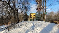
01:34:02 Busov
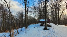
01:52:56 Turistický prístrešok
02:29:15 Cigeľka, rázcestie
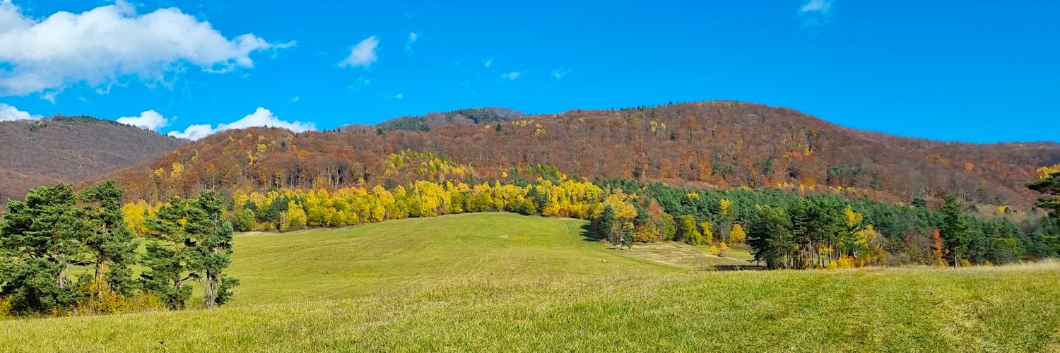
Nízke Beskydy – pohorie v Karpatoch, ktoré sa nachádza v severovýchodnej časti Slovenska a juhovýchodnej časti Poľska. Najvyšším vrchom je Busov (1002 m n. m.).
Tvorí ho komplex krajinných celkov, ktoré sú spojnicou medzi Západnými a Východnými Karpatmi. Zahŕňa tieto krajinné celky na Slovensku: Busov, Ondavská vrchovina, Laborecká vrchovina a Beskydské predhorie. Existujú len dve vegetačné vrstvy: podhorské (do 550 m n. m.) a spodný horský les. Predhorie tvoria zvyšky pôvodných dubových a hrabových lesov, jelšových a prútených húštin v údoliach riek, kým nižšie horské lesy sú jedľové, bukové a borovicové. Početné sú najmä bukové porasty, takmer chýba smrek.
Nízke Beskydy tvoria priečnu morfoštruktúrnu depresiu medzi Východoslovenskou nížinou a Sandomierskou kotlinou. Sú v nich zastúpené len 2 základné tektonické jednotky Karpát – vonkajšie flyšové pásmo na severe a mrenové pásmo na juhu. Diverzifikáciou tektonických pohybov a exogénnych procesov sa tu objavili dva typy reliéfu: erózne brázdy až tektonicko-erózne a pahorkatiny a štruktúrne chrbty až tektonicko-štrukturálne v reliéfe vrchoviny.
Busov – najvyšší vrch Nízkych Beskýd s výškou 1002 m n. m. Nachádza sa v západnej časti pomerne malého rovnomenného pohoria, asi 10 km severozápadne od Bardejova. K masívu Busov patria aj tieto vrcholy: Pálenica (914 m n. m.), Pivnica (857 m n. m.), Vrch Suchej (897 m n. m.) a Pivnica (858 m n. m.). Severnú a východnú časť vrchu odvodňujú prítoky Sveržovky, južným a západným svahom sa voda odvádza do Kamenca. V horných častiach Busova je prevažne zalesnený, v nižších sú rozľahlé čistinky s výhľadom na okolité hory. Na vrchole je malá čistinka s dreveným krížom.
Video natočené 26. októbra 2022.
🇬🇧
Hiking in beautiful autumn colors in the Low Beskid Mountains. From Gaboltov, we follow the green trail to Busov, the highest peak of the Low Beskid Mountains. Initially, we go along the Way of the Cross through beautiful and scenic glades. Then we enter a colorful forest, pass a spring by the trail and climb the western ridge to the top. From the top we go down the northern slopes along the valley of the Vovčinec stream to the village of Cigeľka.
🚶 Virtual hike: Ascent to Busov Mountain from Gaboltov, Slovakia
🏞️ Route: Gaboltov, parking (400 m a.s.l.; 49.365051, 21.142491) – Gaboltov, Way of the Cross (482 m a.s.l.; 49.370309, 21.144449) – Spring (847 m a.s.l.; 49.388606, 21.156433) – Busov Mountain (1002 m a.s.l.; 49.388065, 21.162580) – Tourist shelter (878 m a.s.l.; 49.389556, 21.167344) – Cigeľka, crossroads (509 m a.s.l.; 49.398700, 21.143199)
🆔 Trail designation: green trail
📏 Length: about 7.5 km
⏲️ Walking time: about 3:00 h
↗️ Sum of approaches: 601 m
↘️ Sum down: 467 m
00:00:23 Gaboltov, parking
00:00:45 Bus stop
00:04:21 The beginning of the Way of the Cross
00:14:32 Going of the trail
00:19:51 The end of the Way of the Cross
00:21:41 Return to the green trail
01:13:35 Spring
01:34:02 Busov Mountain
01:52:56 Tourist shelter
02:29:15 Cigeľka, crossroads
Low Beskid Mountains – a mountain range in the Carpathians, located in the north-eastern part of Slovakia and south-eastern part of Poland. The highest peak is Busov (1002 m a.s.l.).
It consists of a complex of landscape units that are a link between the Western and Eastern Carpathians. It includes the following landscape units in Slovakia: Busov, Ondavská vrchovina, Laborecká vrchovina and Beskydské predhorie. There are only two vegetation layers: the foothills (up to 550 m above sea level) and the lower montane forest. The foothills are made up of the remains of original oak and hornbeam forests, alders and wicker thickets in the river valleys, while the lower montane forests are fir, beech and pine forests. Beech stands are particularly numerous, and spruce is almost absent.
The Low Beskid Mountains form a transverse morphostructural depression between the East Slovak Lowland and the Sandomierz Basin. Only 2 basic tectonic units of the Carpathians are represented in them – the outer flysch belt in the north and the barbel belt in the south. The diversification of tectonic movements and exogenous processes resulted in the appearance of two types of relief here: erosion furrows to tectonic-erosive and hilly basins, and structural ridges to tectonic-structural in upland relief.
Busov – the highest peak of the Low Beskid Mountains with a height of 1002 m a.s.l. It is located in the western part of a relatively small mountain range of the same name, about 10 km northwest of Bardejov. The Busov massif also includes the following peaks: Pálenica (914 m a.s.l.), Pivnica (857 m a.s.l.), Vrch Suchej (897 m aa.s.l.) and Pivnica (858 m a.s.l.). The northern and eastern parts of the mountain are drained by the Sveržovka tributaries, while the southern and western slopes drain water into Kamenec. In the upper parts of Busov is mostly forested, in the lower parts there are vast glades with views of the surrounding mountains. At the top there is a small glades with a wooden cross.
The film was recorded on October 26, 2022.