
🇵🇱
🚶 Wirtualna wędrówka: Wejście na Stożek Wielki z Wisły, Polska
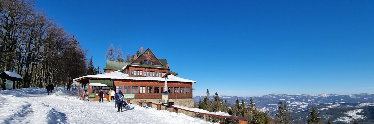
🏞️ Trasa: Wisła Łabajów, parking (600 m n.p.m.; 49.609556, 18.845630) – Skrzyżowanie szlaków pod Stożkiem Wielkim (898 m n.p.m.; 49.607549, 18.823973) – Stożek Wielki (978 m n.p.m.; 49.605559, 18.823094) – Schronisko PTTK na Stożku (957 m n.p.m.; 49.604259, 18.823211)
🆔 Oznaczenie: zielony szlak
📏 Długość: około 2,6 km
⏲️ Czas przejścia: około 1:20 h
↗️ Suma podejść: 381 m
↘️ Suma zejść: 28 m
00:00:22 Wisła Łabajów, parking
00:34:25 Zejście ze szlaku
00:37:42 Powrót na zielony szlak
00:45:20 Skrzyżowanie czerwonego, zielonego i żółtego szlaku pod Stożkiem Wielkim
00:59:59 Zejście ze szlaku
01:03:08 Stożek Wielki
01:08:30 Powrót na zielony i czerwony szlak
01:08:42 Schronisko PTTK na Stożku
Beskid Śląski (Slezské Beskydy) – pasmo górskie, stanowiące część Beskidów Zachodnich, wchodzące w skład Karpat Zachodnich. Najwyższym szczytem Beskidu Śląskiego jest Skrzyczne (1257 m n.p.m.). Graniczy z Beskidem Śląsko-Morawskim na zachodzie, Beskidem Żywieckim na południowym wschodzie, Kotliną Żywiecką na wschodzie, Beskidem Małym na północnym wschodzie i Pogórzem Śląskim na północy.
Beskid Śląski zbudowany jest z masywnych piaskowców godulskich i istebniańskich. W części południowej góry zbudowane są z fliszu magurskiego. Występują tu złoża mineralne: piaskowce, wapienie i kruszywa naturalne. Występują tu stosunkowo licznie i miejscami dość rozbudowane wychodnie skalnych, a także największa na terenie polskich Beskidów koncentracja jaskiń, wśród których znajdują się m.in. dwie największe jaskinie polskiego fliszu karpackiego Jaskinia Wiślańska oraz Jaskinia Miecharska.
Beskid Śląski składa się z dwóch rozciągniętych południkowo pasm górskich, rozdzielonych doliną rzeki Wisły. Na zachodzie znajduje się Pasmo Czantorii, natomiast na wschodzie Pasmo Baraniej Góry, zwane też czasem Pasmem Wiślańskim.
Na stokach Baraniej Góry znajdują się tereny źródliskowe Wisły.
Stożek Wielki (Velký Stožek) – szczyt o wysokości 978 m n.p.m. w Beskidzie Śląskim. Jest trzecim co do wysokości szczytem w Paśmie Czantorii, po Wielkiej Czantorii (995 m n.p.m.) i Kiczorach (990 m n.p.m.). Znajduje się na granicy polsko-czeskiej.
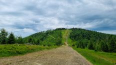
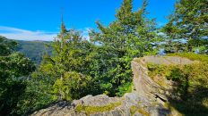
Zbocza Stożka Wielkiego stromo opadają ku zachodowi, północy i wschodowi, jedynie ku południu jego grzbiet biegnie prawie poziomo ku Kyrkawicy. Szczyt, widziany zwłaszcza od północnej strony, ma formę dość regularnego stożka. Pod samym szczytem od zachodniej strony znajduje się wychodnia skalna zbudowana z piaskowca godulskiego.
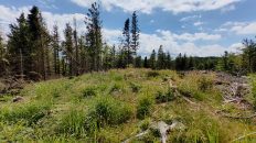
Góra po zachodniej strony porośnięta jest lasem bukowo-świerkowym a po wschodniej świerkowym. W wyniku niszczycielskiego działania kornika drukarza większość świerków uschła. Dzięki temu odsłoniły się niedostępne jeszcze kilka lat temu widoki zarówno na Beskid Śląski jak i na czeski Beskid Śląsko-Morawski a także przy dobrych warunkach pogodowych na Beskid Żywiecki i Tatry. W niższych partiach stoków znajdują się pastwiska i grunty orne, w wielu miejscach występują osiedla góralskie.
Film zarejestrowany w dniu 15 lutego 2023 roku.
🇬🇧
Winter hiking in beautiful weather in the Silesian Beskid Mountains. From Wisła Łabajów we go along the green, very scenic trail to Stożek Wielki Mountain. Initially, the trail leads through the higher-lying housing estates of the Vistula River. From approximately 800 m a.s.l. fantastic panoramas of the Silesian Beskids appear. In front of the shelter you can also see Babia Góra, Pilsko and the Tatra Mountains. An unmarked path leads to the top, from which you can also admire the panoramas of the Czech Moravian-Silesian Beskid Mountains with the dominant Lysá hora Mountain through the thinned trees. The first part of the hike ends at the PTTK shelter in Stożek.
🚶 Virtual hike: Ascent to Stożek Wielki Mountain from Wisła, Poland
🏞️ Route: Wisła Łabajów, parking (600 m a.s.l.; 49.609556, 18.845630) – Crossing of trails at Stożek Wielki (898 m a.s.l.; 49.607549, 18.823973) – Stożek Wielki Mountain (978 m a.s.l.; 49.605559, 18.823094) – PTTK Mountain Shelter on Stożek (957 m a.s.l.; 49.604259, 18.823211)
🆔 Trail designation: green trail
📏 Length: about 2.6 km
⏲️ Walking time: about 1:20 h
↗️ Sum of approaches: 381 m
↘️ Sum down: 28 m
00:00:22 Wisła Łabajów, parking
00:34:25 Going off the trail
00:37:42 Return to the green trail
00:45:20 Crossing of the green, yellow and the red trails at Stożek Wielki
00:59:59 Going off the trail
01:03:08 Stożek Wielki Mountain
01:08:30 Return to the red and the green trails
01:08:42 PTTK Mountain Shelter on Stożek
Silesian Beskid Mountains (Slezské Beskydy) – a mountain range, which is part of the Western Beskids, part of the Western Carpathians. The highest peak of the Silesian Beskids is Skrzyczne (1257 m a.s.l). It borders the Silesian-Moravian Beskids to the west, the Żywiec Beskid Mountains to the southeast, the Żywiec Valley to the east, the Mały Beskid Mountains to the northeast and the Silesian Foothills to the north.
The Silesian Beskid Mountains are built of massive Godul and Istebna sandstones. In the southern part, the mountains are made of Magura flysch. There are mineral deposits here: sandstones, limestones and natural aggregates. There are relatively numerous and in some places quite extensive rock outcrops, as well as the largest concentration of caves in the Polish Beskids, among which there are, among others, the two largest caves of the Polish Carpathian flysch, Jaskinia Wiślańska and Jaskinia Miecharska.
The Silesian Beskid Mountains consist of two meridional mountain ranges, separated by the valley of the Vistula River. In the west there is the Czantoria Range, while in the east there is the Barania Góra Range, sometimes also called the Vistula Range.
On the slopes of Barania Góra there are spring areas of the Vistula.
Stożek Wielki Mountain (Velký Stožek) – a peak with a height of 978 m a.s.l. in the Silesian Beskid Mountains. It is the third highest peak in the Czantoria Range, after Wielka Czantoria (995 m a.s.l) and Kiczory (990 m a.s.l). It is located on the Polish-Czech border.
The slopes of Stożek Wielki fall steeply to the west, north and east, only to the south its ridge runs almost horizontally towards Kyrkawica. The peak, seen especially from the north, has the form of a fairly regular cone. Just below the top, on the western side, there is a rock outcrop made of Godulski sandstone.
The mountain on the western side is covered with a beech and spruce forest, and on the eastern side it is covered with a spruce forest. As a result of the destructive action of the spruce bark beetle, most of the spruces withered. As a result, views of both the Silesian Beskids and the Silesian-Moravian Beskids, which were inaccessible only a few years ago, were revealed, as well as, in good weather conditions, the Żywiec Beskids and the Tatras. In the lower parts of the slopes there are pastures and arable land, in many places there are highland settlements.
The film was recorded on February 15, 2023.