
🇨🇿
🚶 Virtuální túra: Sestup z Pradědu přes Malý Děd do osady Vidly, Česká republika
🏞️ Trasa: Praděd (1491 m n.m.; 50.082943, 17.231751) – Praděd, rozc. (1419 m n.m.; 50.083687, 17.222043) – Švýcárna (1305 m n.m.; 50.101423, 17.214173) – Malý Děd, vedle vrcholu (1364 m n.m.; 50.102835, 17.219625) – Černík (1211 m n.m.; 50.107061, 17.228244) – Střední Opava (943 m n.m.; 50.099541, 17.241392) – Vidly (770 m n.m.; 50.105118, 17.269552)
🆔 Označení stezky: zelená stezka, červená stezka, modrá stezka,
📏 Délka: cca 8,8 km
⏲️ Doba chůze: cca 2:40 h
↗️ Suma přístupů: 43 m
↘️ Sestup: 764 m
00:00:21 Praděd
00:01:24 Vyhlídka na televizní věži
00:36:30 Praděd, rozc.
00:36:42 Křížení zelené a červené stezky
01:04:57 Švýcárna
01:06:28 Křížení modré, žluté, zelené a červené stezky
01:16:06 Malý Děd, vedle vrcholu
01:31:46 Česnekový potok
01:34:54 Černík
01:35:04 Křížení modré a žluté stezky
01:35:43 Česnekový potok
01:59:57 Potok
02:07:30 Střední Opava
02:09:51 Střední Opava
02:34:52 Vidly
Hrubý Jeseník – mezoregion, který je součástí Východních Sudet a pohoří Jeseníky. Nachází se v severovýchodních Čechách – na pomezí Moravy a Slezska, v Olomouckém a Moravskoslezském kraji. Na severozápadě je ohraničeno Zlatými horami, na severu a severovýchodě Opavským pohořím, na východě a jihovýchodě Nízkým Jeseníkem a na západě a jihozápadě Hanušovickou vrchovinou. . Nejvyšším vrcholem je Praděd, 1 491 m n. m., s televizní věží Praděd, vysokou 146 m.
Podle geomorfologického členění navrženého prof. Jaromíra Demka byly ve Vysokém Jeseníku identifikovány tyto mikroregiony a jejich části: Keprnická hornatina, Medvědská hornatina, Pradědská hornatina.
Geologicky patří Hrubý Jeseník do geologického celku Východní Sudety (silesikum). Je budován metamorfovanými horninami, především rulami, různými druhy slídových břidlic, amfibolitů, kvarcitů, mramorů a dalších. Krajní východní část je budována slabě metamorfovanými sedimentárními horninami slezskomoravského pásma (andelskohorské souvrství), především fylity, metablatníky, jílovité kovové břidlice, ojediněle jemnozrnné pískovce.
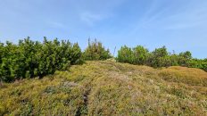
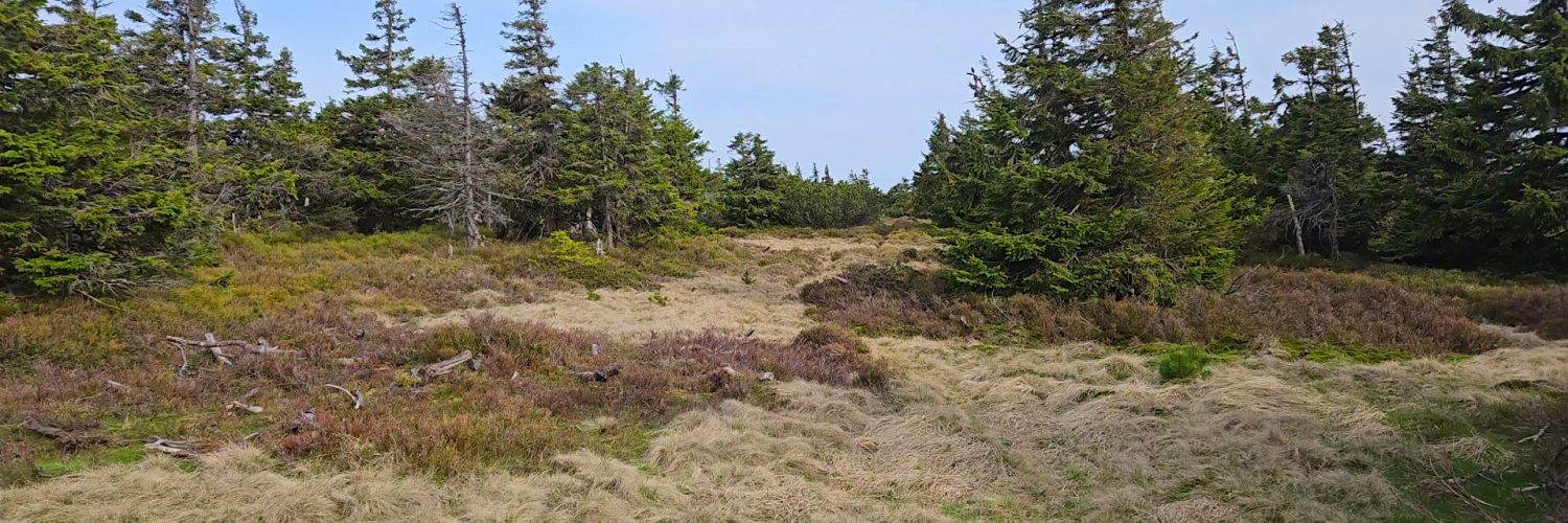
V oblasti Hrubého Jeseníku se díky své výšce vyskytují vegetační vrstvy. Podhůří jsou nyní louky a orná pole. Dolní montánní pásmo dříve tvořily smíšené lesy s převahou buku, které byly většinou nahrazeny smrkovými lesy. Horní montánní pásmo je v současnosti tvořeno smrkovými lesy vysázenými člověkem. Poblíž horní hranice horského lesa nabývají smrky zakrslou podobu, utvářenou zde vanoucími větry. Doprovázejí je typické horské druhy, jako je bříza karpatská, slezská vrba nebo jeřáb. Ve svrchním subalpínském pásmu dominují bylinné druhy a skalní lišejníky. Původně se v Jeseníkách nevyskytovala borovice horská, která zde byla vysazena na přelomu 19. a 20. století.
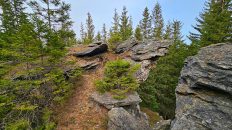
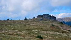
Malý Děd – vrchol s výškou 1369 m n. m. v Hrubém Jeseníku, na severovýchodě České republiky, ve východních Sudetech. Nachází se na hlavním hřebeni hory Praděd, mezi vrcholy Pradědu a Velkého Jezerníku.
Hora sousedí ze severovýchodu s údolím řeky Bělé a sedlem Videlské sedlo, údolím Česnekového potoka a sedlem 1167 m n. m. od západu směrem na Kamzičí vrch, od jihovýchodu s průsmykem 1341 m n.m. směrem k vrcholu Praděd, od jihozápadu údolím Česnekového potoka, od západu průsmykem Sedlo Velký Jezerník a údolím Studeného potoka a průsmykem vysokým 1253 m na severu směrem k vrcholu Nad Vodopádem.
Masiv Malého Dědu je tvořen metamorfovanými horninami, především: fylity, fylonity, ruly; zelené břidlice; vyvřelé horniny, hlavně: metadiabasy a sedimentární horniny, hlavně: metaarkózy.
Vrchol je porostlý vzácnými smrky a hustou alpskou trávou a borovicí horskou. Turistická trasa prochází asi 180 m od vrcholu, z důvodu ochrany zde zřízeného cenného ekosystému národní přírodní rezervace Praděd je na vrchol zakázán vstup.
Svahy hory jsou převážně zalesněné hustým smrkovým lesem. Pouze na úpatí jihozápadního svahu jsou větší fragmenty smíšeného lesa.
Film byl natočen 22. května 2023.
🇬🇧
The second part of the spring hike in the High Ash Mountains in the Czech Republic. We descend the green trail from Praděd to the crossroads below the peak and continue along the red trail to the Švýcárna shelter. Then follow the blue trail to Malý Děd. Due to nature protection, the trail bypasses the peak from the north-west. We descend from the top along the Česnekový Stream and at the crossroads of the Černík, heading east, we descend along Střední Opava to the village of Vidly.
🚶 Virtual hike: Descent from Praděd through Malý Děd to the settlement of Vidly, Czech Republic
🏞️ Route: Praděd Mountain (1491 m a.s.l.; 50.082943, 17.231751) – Praděd, rozc. (1419 m a.s.l.; 50.083687, 17.222043) – Švýcárna (1305 m a.s.l.; 50.101423, 17.214173) – Malý Děd, next to the summit (1364 m a.s.l.; 50.102835, 17.219625) – Černík (1211 m a.s.l.; 50.107061, 17.228244) – Střední Opava (943 m a.s.l.; 50.099541, 17.241392) – Vidly (770 m a.s.l.; 50.105118, 17.269552)
🆔 Trail designation: green trail, red trail, blue trail
📏 Length: about 8.8 km
⏲️ Walking time: about 2:40 h
↗️ Sum of approaches: 43 m
↘️ Sum down: 764 m
00:00:21 Praděd Mountain
00:01:24 Viewpoint on the TV tower
00:36:30 Praděd, rozc.
00:36:42 Crossing of the green and the red trails
01:04:57 Švýcárna
01:06:28 Crossing of the green, red, yellow and the blue trails
01:16:06 Malý Děd, next to the summit
01:31:46 Česnekový potok
01:34:54 Černík
01:35:04 Crossing of the yellow and the blue trails
01:35:43 Česnekový potok
01:59:57 Stream
02:07:30 Střední Opava
02:09:51 Střední Opava
02:34:52 Vidly
High Ash Mountains – a mesoregion that is part of the Eastern Sudetes and the Jeseníky mountain range. It is located in north-eastern Bohemia – on the border of Moravia and Silesia, in the Olomouc and Moravian-Silesian regions. It is bordered to the north-west by the Golden Mountains, to the north and north-east by the Opava Mountains, to the east and south-east by the Low Jeseník Mountains, and to the west and south-west by the Hanušovická vrchovina. The highest peak is Praděd, 1491 m a.s.l., with the Praděd TV Tower, 146 m high.
According to the geomorphological division proposed by prof. Jaromír Demek, the following microregions and its parts have been identified in the High Ash Mountains: Keprnická hornatina, Medvědská hornatina, Pradědská hornatina.
Geologically, Vysoky Jeseník belongs to the geological unit of the Eastern Sudetes (silesikum). It is built of metamorphic rocks, mainly gneisses, various types of mica schists, amphibolites, quartzites, marbles and others. The extreme eastern part is built of poorly metamorphosed sedimentary rocks belonging to the Silesian-Moravian zone (Andelskohorská Formation), mainly phyllites, metamudstones, clay metal shales, and occasionally fine-grained sandstones.
In the area of the High Ash Mountains, due to its height, there are vegetation layers. The foothills are now meadows and arable fields. The lower montane zone formerly consisted of mixed forests, with a predominance of beech, which were mostly replaced by spruce forests. The upper montane zone is currently made up of spruce forests planted by man. Near the upper limit of the montane forest spruces assume a dwarf form, shaped by the winds blowing here. They are accompanied by typical mountain species, such as the Carpathian birch, Silesian willow or rowan. Herbaceous species and rock lichens dominate in the upper subalpine zone. Originally, there was no mountain pine in Jeseníky, which was planted here at the turn of the 19th and 20th centuries.
Malý Děd – a peak with a height of 1369 m a.s.l. in the High Ash Mountains, in the north-eastern Czech Republic, in the Eastern Sudetes. It is located on the main ridge of Mount Praděd, between the peaks of Praděd and Velký Jezerník.
The mountain is adjacent to the valley of the Bělá River and the Videlské sedlo pass from the north-east, the valley of the Česnekový potok stream and the pass 1167 m a.s.l. from the west towards Kamzičí vrch, from the south-east with a pass 1341 m a.sl. towards the Praděd peak, from the south-west with the Česnekový potok valley, from the west with the Sedlo Velký Jezerník pass and the Studený potok valley, and with the 1253 m high pass in the north towards the peak of Nad Vodopádem.
The Malý Děd massif is made of metamorphic rocks, mainly: phyllites, phyllonites, gneisses; greenschists; igneous rocks, mainly: meta-diabases and sedimentary rocks, mainly: meta-arcoses.
The peak is overgrown with rare spruce trees and dense alpine grass and mountain pine. The hiking trail passes about 180 m from the peak, due to the protection of the valuable ecosystem of the Praděd national nature reserve established here, access to the peak is prohibited.
The slopes of the mountain are mostly forested with dense spruce forest. Only at the foot of the south-western slope there are larger fragments of mixed forest.
The film was recorded on May 22, 2023.